
from Israel Post; these stamps will be issued February 7, 2017:
 In 1972, the United Nations Educational, Scientific and Cultural Organization (UNESCO) approved an agreement to protect world heritage sites. The program included rules to assess natural and cultural sites and determine their significance to mankind’s common cultural heritage. Every country prepares a list of its sites and once a year the UNESCO World Heritage Center conducts a special meeting to choose which of the nominated sites shall be included in the list of United Nations World Heritage Sites.
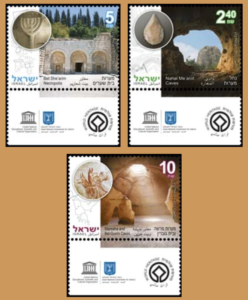
In 1999, Israel joined the agreement and submitted sites for consideration, and since 2001 a number of Israeli sites have been added to the list: Old City of Acre (2001), Masada (2001), White City of Tel Aviv (2003), Biblical Tels ñ Megiddo, Hazor, Beer Sheba (2005), Incense Route ñ Desert Cities in the Negev (Avdat, Mamshit, Haluza and Shivta) (2005), Baha’i Holy Places (2008), Nahal Me’arot Caves (2012), Maresha and Bet-Guvrin Caves (2014), Bet She’arim Necropolis (2015).
Nahal Me’arot Caves
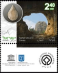 Four caves are carved into the mountain on the southern slope of Mount Carmel, at the entrance to the Nahal Me’arot Caves. Archeological excavations conducted at the site from 1928 to the present have discovered evidence of human existence near and inside the caves over hundreds of thousands of years. Among the many findings were remnants of houses, various stone tools, jewelry, bones of animals used for food and graves.
Bet She’arim Necropolis
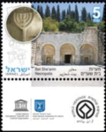 Rabbi Yehudah Hanasi, leader of the Jewish people in the late 2nd century CE, was buried at his behest in the cemetery in the town of Bet She’arim in the western Jezreel Valley. Many others subsequently asked to be buried near the final resting place of the admired leader. Dozens of burial caves were carved into the hillsides and on the outskirts of the town. Jews were brought from all over Eretz Israel and even from faraway lands to be buried there. The hundreds of epitaphs found in the caves provide information about the Jewish lifestyle in the 3rd and 4th centuries CE.
Maresha and Bet-Guvrin Caves
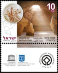 Residents of the city of Maresha, in the southern Judean plain, carved many spaces beneath their homes into the soft chalk bedrock upon which the city was built. These spaces served as water reservoirs, agricultural production facilities, storage rooms, pigeon raising, burial caves and more. After Maresha was destroyed in the 1st century BCE a new city called Bet-Guvrin was constructed nearby. In the Byzantine period, the townspeople carved bricks out of the chalk in deep, bell-shaped caves.
In June 2007, Acre, Tel Aviv and Masada stamps were issued as part of the World Heritage Site stamp series and in August 2007 the Biblical Tels and Incense Route stamps were added.
Description of the Stamps
Nahal Me’arot Caves The view from inside the cave toward the Nahal Me’arot Caves landscape (photo by Ronen Goldberg).
Carved flint hand axe from the Lower Paleolithic period found in the Tabun Cave. (photo: Midad Sokolovski; courtesy of the Israel Antiquities Authority).
Topographic map of Nahal Me’arot Caves (based on an Israel Antiquities Authority map).
Bet She’arim Necropolis
FaÁade of the Sarcophagi Cave, cave number 20 (courtesy of the Nature and Parks Authority, photo: Tsvika Tsuk).
Plaster relief in the shape of a menorah in the Sarcophagi Cave (photo: Shutterstock).
Partial diagram of the caves (based on a sketch in a Nature and Parks Authority pamphlet).
Maresha and Bet-Guvrin Caves
Bell cave in Bet-Guvrin (photo: Shutterstock).
Cave drawing of Cerberus, mythological hound that guards the gates of the underworld, from the Sidon Burial Cave (courtesy of the Nature and Parks Authority, photo: Jonny Limonik).
Partial diagram of the caves in the Maresha and Bet-Guvrin area (based on a sketch in a Nature and Parks Authority pamphlet).


